OpTIS Land Use Data Pilot Nears Release
For decades, CTIC distributed the CRM Survey, data on conservation practices that had been gathered by hundreds of conservationists in painstaking transect surveys. Today, CTIC, Applied GeoSolutions (AGS) and The Nature Conservancy are collaborating on a new effort to take crop residue and cover crop surveys into the space age, using data gathered by multiple satellites and processed through AGS's validated calculations.
The Operational Tillage Informational System (OpTIS) produces accurate, timely maps of crop emergence, crop residue and winter cover crops using publicly available satellite data. Data are aggregated to county or watershed resolution to protect the privacy of individual farmers.
OpTIS data can be helpful to many users, including:
- Soil and water conservation districts establishing program priorities and evaluating progress in achieving conservation goals.
- Federal and state agencies comparing the effectiveness of conservation programs across large regions.
- The agri-food supply chain developing environmentally sustainable sourcing programs.
- Environmental groups focusing efforts to improve soil health and water quality.
- Academic researchers studying the impacts of conservation practices on soil health or water quality.
Remote sensing provides data on conservation practices through the new OpTIS project.
"We know that improving soil health on America's farmland can significantly improve our water quality, store more carbon, and help farmers sustainably produce more food," said Pipa Elias, soil health strategy lead for The Nature Conservancy. "OpTIS is an important, innovative technology that will empower an array of stakeholders, including conservation organizations, with the information they need to efficiently provide farmers with the tools they need to adopt proven soil health practices."
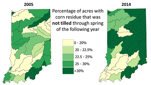
AGS and CTIC conducted a pilot project to test, ground-truth and document the capabilities of OpTIS using remote sensing data and archived land use information across the state of Indiana. These Indiana data, covering 2005 through 2015, will be available on CTIC's new website, which is due to launch soon.
Phase 1 data, covering the entire U.S. Corn Belt from 2005 to 2017, will be available through a simple, flexible interface on the CTIC website by April 2019. Phase 2, covering all U.S. counties with more than 5,000 acres of row crops, is targeted for release in 2021.
Watch www.ctic.org for the release of OpTIS data. For more information, contact Dave Gustafson at CTIC.