OPTIS CVN
OpTIS 2.1—FEATURING 2020 DATA—WILL BE ONLINE FREE BY YEAR-END
A new year's worth of remote sensing data on tillage and winter cover crops from the Operational Tillage Information System (OpTIS) will be available by the end of December, expanding the dataset that extends back to 2005 across the Corn Belt.
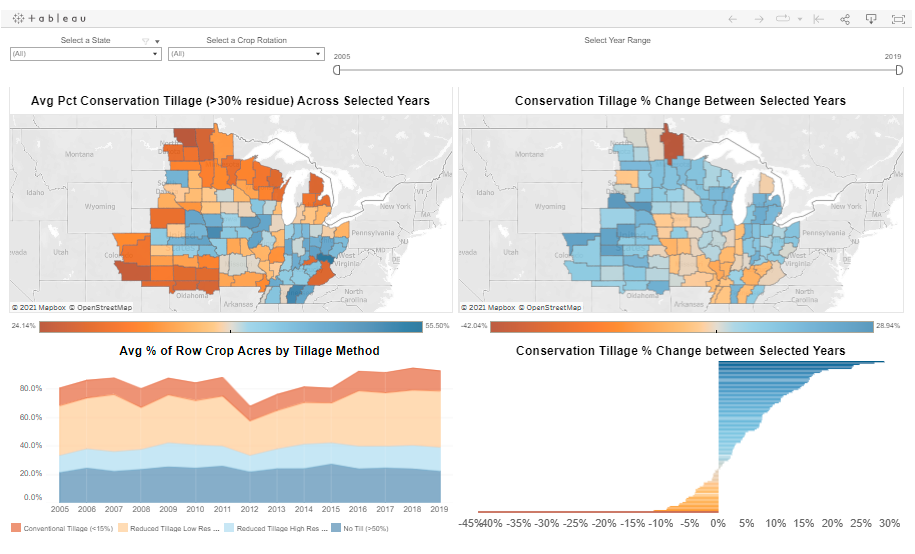
A powerful, intuitive visualization tool on the CTIC website allows visitors to explore trends in tillage and cover crop adoption through maps and charts while manipulating geography, date range and crop rotation. OpTIS data will be visibe on our interactive portal at the HUC 8 or USDA crop reporting district level. The visualization tool also allows the user to see changes in soil carbon and other variables based on the level of adoption of conservation practices, as predicted by the De-Nitrification/De-Composition (DNDC) model via the visualization tool.
OpTIS runs publicly available remote sensing data through a unique algorithm to track trends in tillage practices and the adoption of cover crops. The system was developed by Regrow Ag in collaboration with CTIC and The Nature Conservancy (TNC). Click here for more about OpTIS.
CTIC LAUNCHES CONSERVATION VALIDATION NETWORK WITH KICKOFF WORKSHOP
Over the past year, CTIC and The Nature Conservancy (TNC) have been talking with partner organizations to create the Conservation Validation Network (CVN), a valuable set of anonymized ground-truthing data that can support advances in remote sensing methodologies being used to track the adoption of regenerative conservation practices.
With seed money from TNC Indiana and Corteva, we’re pleased to announce that CTIC is now leading a CVN Indiana Pilot.
The project has three deliverables:
- A CVN kickoff workshop
- Creating the database
- Launching a webpage to enroll farmers
On August 25, 2021, CTIC hosted the CVN Kickoff Workshop at the Purdue Research Park. Approximately 40 participants joined either in-person or through Zoom, with morning presentations from CTIC, the Indiana State Department of Agriculture (ISDA), Regrow Ag, Indigo, Iowa State, the U.S. Geological Survey (USGS) and OpenTEAM. During the afternoon session, the project partners (CTIC, Arva and Corteva) presented the initial CVN database design for feedback.
“We were greatly encouraged by the strong level of interest and spirit of collaboration experienced by the 40 participants in the CVN Kickoff Workshop," says Dave Gustafson, CTIC Project Director for CVN. "It was wonderful to see so many others sharing our vision about the tremendous value that anonymized ground-truthing data would bring, by supporting advances in the remote sensing methodologies being used to track adoption of regenerative conservation practices like reduced tillage and winter cover crops.”
With the expected launch of the enrollment webpage in early 2022, CTIC will be seeking help to encourage farmer participation in CVN from across the state of Indiana. In the meantime, any updates will continue to be posted to the project’s current webpage: https://ctic.org/projects/ConservationValidationNetwork.